Featured Maps! Plate Tectonics & Earthquakes
Theme for the week: Plate Tectonics & Earthquakes
March 1-16, 2018
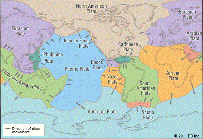
The feeling of the ground shaking can be a scary experience. But have you ever wondered how or why earthquakes happen in the first place? According to National Geographic Society, earthquakes occur near tectonic plates boundaries, slabs of rocky crust that fit together to form the Earths outer shell. Plates, moving by mere inches annually, can grind, collide, separate, and scrape pass one another. Through these interactions, the more strains it builds results in vibrations, known as earthquakes. Some major plates are the Northern American and the Pacific Plate. Although earthquakes are watched closely, they are still hard to predict.
Did you know: In Fort Tejon California, north of LA, had a magnitude of 8.3 earthquake in 1857?
Come explore and learn more about earthquakes from these artistic maps that depict selected earthquakes in the U.S with a magnitude of 7.8 or greater, from 1897-1996, or a map that illustrates how moderate magnitude earthquakes can produce serious effects in Los Angeles, as well as a map that anticipates loss from future earthquakes. My favorite map is the colorful stress map that estimates the differential stress levels in the lithosphere, where earthquakes occur, and by researching the variations of unstable to stable frictional slips on faults can explain the occurrence of ductile earthquakes. Also available is a map that points out previous earthquakes that had generated tsunamis.
Did you know: That since 1971, earthquakes has produced over $55 billion in losses in California, and expect damage to exceed $30 billion in 10 years!
Earth’s tectonic plates
Come to the Map Collection and look for this sign:

Maps
Title: World Stress Map-Maximum Horizontal Stress Orientation
by Mary Lou C. Zoback, and American Geophysical Union (1992)
Call Number: MAP G3201.C55 1992 .Z6 (Explanatory text included; pp 11749)
Title: The earth’s fractures surface; Living on the edge
by National Geographic Society (U.S.). Cartographic Division, John F. Shupe, Peter W. Sloss, and Robert Stacey (1995)
Call Number: MAP G3201.C55 1995 .N2
Title: A century of great earthquakes, 1897-1996
by Robert P. Massé, James W. Dewey, and Unique Media Incorporated (1996)
Call Number: MAP G3201.C55 1996 .M2
Title: Earthquakes in the conterminous United States
by Susan K. Goter, et al. (1991)
Call Number: MAP G3701.C55 1991 .G6
Title: Epicenters of and areas damaged by M > 5 California earthquakes, 1800- 1999
by Tousson R. Toppozada, and Division of Mines and Geology (2000)
Call Number: MAP G4361.C5 sVar .C3 no.49 (Vert. File)
Title: Earthquakes in California and Nevada
by Susan K. Goter, et al. (1984)
Call Number: MAP G4361.C55 1994 .G6
Title: Earthquake shaking potential for California, Spring 2003
by Seismic Safety Commission (2002)
Call Number: MAP G4361.C55 2002 .C2
Title: San Francisco Bay area earthquakes
by Geological Survey, Environmental Research Institute of Michigan, National Geographic Society (1990)
Call Number: MAP G4362.S35C55 1990 .U6
Title: Preliminary map of Pleistocene to Holocene faults in the Lake Tahoe basin, California and Nevada
by R. A. Schweikert (2000)
Call Number: MAP G4362.T15C55 2000 .S2 (Explanatory text included)
Title: Earthquake damage in greater Los Angeles
by Robert P. Massé, James W. Dewey, Unique Media Incorporated, and National Earthquake Information Center (1994)
Call Number: MAP G4364.L8C55 1994 .M2
Title: M7.0 Haiti earthquake of 12 January 2010
by National Earthquake Information Center, and Global Seismographic Network (2010)
Call Number: MAP G4941.C55 2010 .N2
Online: Haiti
Title: The M9.0 great Tohoku earthquake (northeast Honshu, Japan) of March 11, 2011
by National Earthquake Information Center, and Global Seismographic Network (2011)
Call Number: MAP G7961.C55 2011 .U5
Online: Japan
Title: Tsunami-generating earthquakes
by Robert P. Massé, James W. Dewey, and World Data Center A for Seismology (1994)
Call Number: MAP G9231.C55 1994 .M2
Map Collection: Location and Hours
The Map Collection room is normally open to the public in the basement (Lower Level) of Shields Library, Monday-Friday, 1:00-5:00 pm. However, our hours change around the academic calendar and the holiday season. To see the most accurate schedule, please visit the Map Collection.
Contact the Special Collections Department for map related questions by email at speccoll@ucdavis.edu or by phone at 530-752-1621.
Post created by Dawn Collings, Patricia Wyley, and Louis Cashatt.